Date : I8
February 2012.
Walk :Long
Eaton, Sawley, Breaston
OS
Sheet : Explorer 259 and 260
Start
Grid : 448 339 End Grid : 460 339
Distance
(M/k) : 8.0 miles, 12.6k
Ascent (ft) :81 Descent (ft) :54 Excluding bridges
Route
These
notes are provided to enable the walk to be plotted on a 1:25,000 map.
From
the twin roundabouts in the middle of Long Eaton go west on A6005 Derby Road at
the bridge over the canal turn South onto the towpath, follow to Trentlock turn
right along the north bank of River Trent, to the B6540 Tamworth Road, turn
left over the Trent. Follow the south bank of the Trent west under the M1 past
the Aquaduct and on to Longhorse Bridge, cross, turn right along the Trent then
left on to the Trent & Mersey Canal. At the lock cross over the lock gates
taking the path and road to Church Wilne. Pass by the Church to take path on
right to Breaston
Journey
Although
Long Eaton is an old town dating back to before the Doomsday book it is clear
as you walk through it along the Erewash Canal to the River Trent and back over the Trent and
Mersey Canal that in the 1800 hundred’s and early twentieth century it must
have been a very busy industrial town. Even today there appears to be a large
number of small industrial sites and buildings dotted around.
The towpath
is surfaced in gravel bonded to bitmac which is easy for walking. Even on a
cold late winter day there is plenty to see Coots, Moorhens and ducks, walkers,
cyclists and fishermen, a motor boat and a number of canal boats, some occupied
others looking as if they have been laid up for the winter.
As well
as canals Long Eaton appears to be well endowed with railway tracks, on the
Erewash we passed beneath two and as we got closer to the Trent we see a couple
more lines heading for the Trent Crossing and tunnel, where the concrete towers
of Ratcliffe on Soar power station looming over everything.
Walking
up along the Trent we walk under one of the railways again and head for Sawley
Marina for a cup of tea and a warm in front of the fire. Heading out we walk
under the M1, but before we get there we suffer the noise of it, it’s effect
was physical, mind numbing. Moving rapidly on, we spotted a few fishermen
sitting under umbrellas around some fishing lakes formed from old gravel pits.
I bet they were colder and wetter than we were.
As the
Trent swings around to the South the River Derwent comes into it from the North
with alongside it the start (end?) of The Trent & Mersey Canal. A hundred
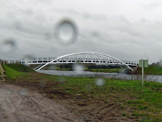
yards or so up the Trent stands the new Longhorse Bridge, looking absolutely
stunning in the rain and murk.
The old
bridge was demolished in 2003 and the new one as built in 2011. See the film of
whole bridge being swung into place Here
The
only way to cross the Trent & Mersey and get to Church Wilne is to walk up
to the Derwent Mouth Lock and cross over the lock gates, a tricky little
exercise.
On
reaching Breaston we headed for The Navigation pub, a super well run little
place with a good atmosphere, good beer and excellent food. Nearly two hours
later we got off the bus just up the road from where we started.
It was
not the best of days to do this walk, we had a few minutes of sun then full on. wind and rain. However, it’s a great anytime
walk, albeit a bit flat and I certainly recommend it. There’s plenty to see and
loads of options to vary or extend the walk as far as you like and as Andy says
being close to home he can get out and do an 8-12 mile walk at almost any time with
little planning or preparation.


